User interface class for OpenLayers maps. More...
 Inheritance diagram for ilOpenLayersMapGUI:
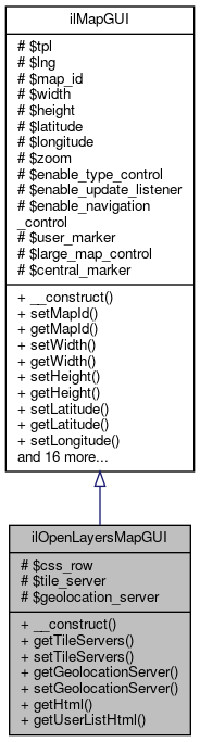 Collaboration diagram for ilOpenLayersMapGUI:
Public Member Functions | |
| __construct () | |
| getTileServers () | |
| setTileServers (string $tile) | |
| getGeolocationServer () | |
| setGeolocationServer (?string $geolocation) | |
| getHtml () | |
| getUserListHtml () | |
| Get User List HTML (to be displayed besides the map) More... | |
| Public Member Functions inherited from ilMapGUI | |
| __construct () | |
| setMapId (string $map_id) | |
| getMapId () | |
| setWidth (string $width) | |
| getWidth () | |
| setHeight (string $height) | |
| getHeight () | |
| setLatitude (string $latitude) | |
| getLatitude () | |
| setLongitude (string $longitude) | |
| getLongitude () | |
| setZoom (?int $zoom) | |
| getZoom () | |
| setEnableTypeControl (bool $enable_type_control) | |
| getEnableTypeControl () | |
| setEnableNavigationControl (bool $enable_navigation_control) | |
| getEnableNavigationControl () | |
| setEnableUpdateListener (bool $enable_update_listener) | |
| getEnableUpdateListener () | |
| setEnableLargeMapControl (bool $large_map_control) | |
| getEnableLargeMapControl () | |
| setEnableCentralMarker (bool $central_marker) | |
| getEnableCentralMarker () | |
| addUserMarker (int $user_id) | |
| getHtml () | |
| getUserListHtml () | |
| Get User List HTML (to be displayed besides the map) More... | |
Protected Attributes | |
| string | $css_row |
| string | $tile_server |
| string | $geolocation_server |
| Protected Attributes inherited from ilMapGUI | |
| ilGlobalTemplateInterface | $tpl |
| ilLanguage | $lng |
| string | $map_id |
| string | $width |
| string | $height |
| string | $latitude |
| string | $longitude |
| int | $zoom |
| bool | $enable_type_control |
| bool | $enable_update_listener |
| bool | $enable_navigation_control |
| array | $user_marker |
| bool | $large_map_control |
| bool | $central_marker |
Detailed Description
User interface class for OpenLayers maps.
Definition at line 25 of file class.ilOpenLayersMapGUI.php.
Constructor & Destructor Documentation
◆ __construct()
| ilOpenLayersMapGUI::__construct | ( | ) |
Definition at line 31 of file class.ilOpenLayersMapGUI.php.
References ILIAS\GlobalScreen\Provider\__construct().
Here is the call graph for this function: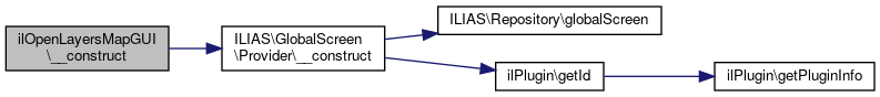
Member Function Documentation
◆ getGeolocationServer()
| ilOpenLayersMapGUI::getGeolocationServer | ( | ) |
Definition at line 51 of file class.ilOpenLayersMapGUI.php.
References $geolocation_server.
Referenced by getHtml().
Here is the caller graph for this function: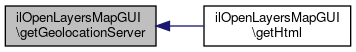
◆ getHtml()
| ilOpenLayersMapGUI::getHtml | ( | ) |
Definition at line 62 of file class.ilOpenLayersMapGUI.php.
References ilMapGUI\$central_marker, $user_id, ilObject\_exists(), ilMapGUI\getEnableCentralMarker(), ilMapGUI\getEnableNavigationControl(), ilMapGUI\getEnableUpdateListener(), getGeolocationServer(), ilMapGUI\getHeight(), ilMapGUI\getLatitude(), ilMapGUI\getLongitude(), ilMapGUI\getMapId(), getTileServers(), ilMapGUI\getWidth(), ilMapGUI\getZoom(), and ILIAS\Repository\lng().
Here is the call graph for this function:
◆ getTileServers()
| ilOpenLayersMapGUI::getTileServers | ( | ) |
Definition at line 40 of file class.ilOpenLayersMapGUI.php.
References $tile_server.
Referenced by getHtml().
Here is the caller graph for this function:
◆ getUserListHtml()
| ilOpenLayersMapGUI::getUserListHtml | ( | ) |
Get User List HTML (to be displayed besides the map)
Definition at line 177 of file class.ilOpenLayersMapGUI.php.
References $user_id, ilObject\_exists(), and ilMapGUI\getMapId().
Here is the call graph for this function:
◆ setGeolocationServer()
| ilOpenLayersMapGUI::setGeolocationServer | ( | ?string | $geolocation | ) |
Definition at line 56 of file class.ilOpenLayersMapGUI.php.
◆ setTileServers()
| ilOpenLayersMapGUI::setTileServers | ( | string | $tile | ) |
Definition at line 45 of file class.ilOpenLayersMapGUI.php.
Field Documentation
◆ $css_row
|
protected |
Definition at line 27 of file class.ilOpenLayersMapGUI.php.
◆ $geolocation_server
|
protected |
Definition at line 29 of file class.ilOpenLayersMapGUI.php.
Referenced by getGeolocationServer().
◆ $tile_server
|
protected |
Definition at line 28 of file class.ilOpenLayersMapGUI.php.
Referenced by getTileServers().
The documentation for this class was generated from the following file:
- components/ILIAS/Maps/classes/class.ilOpenLayersMapGUI.php